What is geospatial data?
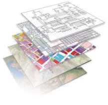
This is a really good question. In a nutshell, it connecting data collected from various geographic resources that have location coordinates and topology that is connected to a particular geographic area. The raw data is then catalogued, analyzed, manipulated and organized to the users’ needs. The processing of this raw data is usually done with Geographic Information Systems (GIS) methods, techniques and technology. Data is then mapped into various layer upon layer. The more layer of data, the more detailed and intricate the organization of data is. GIS assists in interpretation, access and manipulation of raw data. It is “mapping” out the data to be used for whatever the users’ analytical needs are. Raw data is does not have much value, without putting it into context. When you map out raw data, it is easier to see patterns and trends, which puts it into a more useful context. It helps users see what their potential research challenges, issues are and it assists in resolution of these issues by manipulating data without real time consequences.
There are many GIS software and programs that provide GIS capabilities called Desktop GIS, which is usually open source such as Google Earth. Google Earth is not the only open source available; however it is the most widely access and recognized program. There are many commercial GIS software such as ESRI and a more advanced subscription of Google Earth that many companies use in combination with other paid software packages and open source. There are also Web map servers, which are
Geospatial data is used by many different organizations of various sizes, but geospatial data is also used personally too. For example, GPS system built or plugged into a car, a distance tracker for sports such as running, skiing, hiking and cellphones is a geospatial data network of information designed and programmed for a specific use.
So that’s the most simplified description of geospatial data that I can think of, without getting lost in the technical and programming details of it. Please check back to this blog on Fridays for more examples of how geospatial data is used and what other online resources are available to check out what geospatial data is.
